Note: We are not responsible for the above banner!
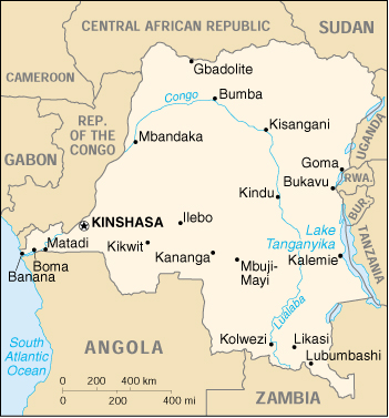
DEMOCRATIC REPUBLIC
OF THE CONGO
Location: Central Africa (0 00 N, 25 00 E)
Land Area: 905,567 square miles (2.35 million square km); approximately Ľ the size of the United States
Capital: Kinshasa (Leopoldville)
Other Important Cities: Lubumbashi, Kisangani, Mbuji-Mayi
Provinces: Bas-Zaire, Bandundu, Equateur, Haut-Zaire, Kinshasa, Kivu, Shaba, East Kasai, West Kasai
Major Rivers: Congo, Ubangi, Kasai
Major Lakes: Tanganyika, Idi Amin Dada (Lake Edward), Mweru
Highest Point: Margherita Peak (16,763 ft; 5,107m)
Main Exports: Copper, coffee, diamonds, cobalt, crude oil
Currency: New Zaire = 100 makuta; 1 US$ approx. 113,000 NZ
Population: 97 million (1997 estimate)
Major Languages: French, Lingala, Kingwana, Kikongo, Tshiluba
Major Religions: Roman Catholic (50%), Protestant (20%), Kimbanguist (10%), Islam (10%), other syncretic sects and traditional beliefs (10%)
Important Leaders:
1960: Patrice Lumumba
1960-1965: Joseph Kasavubu
1964-1965: Moise Tshombe
1965-1997: Mobutu Sese Seko
1997-2001: Laurent Kabila
2001-present: Joseph Kabila